
Working with Geo Documents
Change Map Type
Under the tools tab, you can change how you want to view your geo document. Options are:
- Open Street Map
- Road Map (Here - Map Data)
- Satellite Map (Here - Map Data)
Creating Geo Quotations
For more general information on quotations, see Quotation Level and Working with Quotations.
Creating a Geo quotation is not much different from creating other type of quotations. The only difference is that the quotation is just one location on the map - the place mark, and not a region.
Right-click on the place mark and select the option Create Free Quotation (or click on the Create Free Quotation button in the Document ribbon).
To create further quotations:
inst
Either enter a new address and search for a location of interest, or left-click a point of interest on the map to set a place mark.
Right-click and select Create Free Quotation from the context menu.
If you move your mouse over a quotation, a text window opens displaying information about the quotation like the name, the author, when it was created, any codes and memos that are attached to it, the longitude and latitude and the address.
Display of Geo Q
Geo quotations can be access in the margin area, the Quotation Manager, the Project Explorer, and from within networks. Geo quotations are displayed as follows:
-
The quotation icon shows a place mark.
-
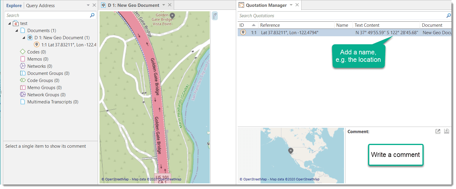
In the Project Explorer, the Quotation Reader and Manager and all reports, geo quotations are referenced in decimal degrees, e.g. LAT 48.859911° LON 2.377317°. In addition, the Quotation Manager shows a preview of the Geo location. You may want to consider renaming Geo quotations, e.g. by adding the name of the location to the coordinates. Another option is to add a comment. See also Working with Multimedia Quotations.
Activating Geo Quotations
Select a Geo quotation in any of the following places and double-click:
- margin area
- Quotation Manager
- Project Explorer
- Network
The quotation will be displayed in context.
An activated place mark is colored in orange. Non-activated place marks are colored in gray.
Modifying a Geo quotation
To modify a Geo quotation, activate it, so it is highlighted in orange.
Move the place mark to a different location. The quotation follows along.
Coding Geo Quotations
For more general information on coding, see Coding Data.
You can also create a quotation and link a code to it in one step, or code an existing quotation:
Set a place mark or select an existing quotation, right-click and select the option Apply Codes (or click on the equivalent coding buttons in the Document ribbon).
All other drag-and-drop operations described for coding also apply.
Creating a Geo
You can create a snapshot from the geographic region that is currently shown on your screen. This snapshot is automatically added as a new image document.
The advantage of the image is that you can select a region as quotation and not only a single point on a map. Further you can browse the Geo location in Google Maps (see below).
Open a Geo document.
In the toolbar, click Snapshot.
A new document is created. The default name is: 'Geo Snapshot @ longitude:latitude' of the last selected location.
As a snapshot results in an image document, you can also handle it like an image document. See for example Creating Image Quotations.
Browsing Geo Locations in Google Map
Create a Geo snapshot.
In the contextual Tools tab, selecting the button Browse Geolocation
This opens Google Maps in your default browser outside of ATLAS.ti.